Makalu Base Camp Trek. This trail Take you to the base camp of world’s fifth highest mountain Makalu. Makalu is a close neighbor of Mt Everest, lying in the north-east region of Nepal. The Makalu Barun National Park, established in 1992, covers the Barun Valley which is part of a huge international protected area under an agreement between Nepal and China. The Park spreads just east to the Everest region, covering areas of the Solukhumbu and Sankhuwasabha districts of Nepal.
One of the most popular trekking peaks of Nepal, the Mera Peak (6654m), also lies in the Makalu Barun region. A large variety of common as well as endangered flora and fauna are protected in the region including rhododendrons, orchids, Snow Leopard, Red Panda, Musk Deer, Wild Boar, Wild Yak, Himalayan Thar, and more than 420 varieties of bird species. Some believe the area also to be home to the elusive Himalayan giant, the Yeti.
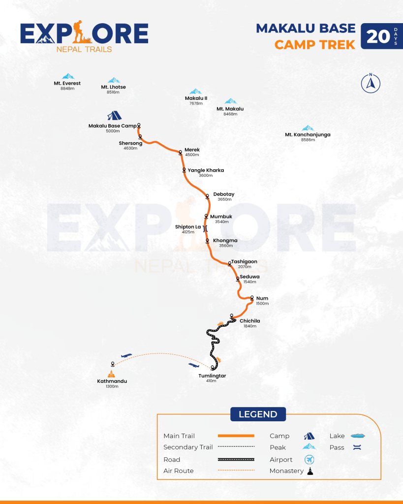
The Makalu Base Camp begins from Tumlingtar of mid-eastern Nepal, an hour’s flight from Kathmandu. The real walking starts from Chichila, a 3-hour’s drive from Tumlingtar. Following the beautiful Barun river valley in the Makalu Barun National Park, we cross various high passes such as Shipton La, Keke La and lakes such as Kalopokhari etc. While trekking, we rise from lowland of Tumlingtar on the Arun River to one of the highest Base Camps on earth, the Makalu Base Camp at 5000m. While on the way to the Makalu Base Camp, you will enjoy the views of the highest mountains such as Mt. Everest, Mt. Lhotse, Mt. Chamlang, Mt. Baruntse and other Himalayan mountains along with Makalu (8481m) itself.
- An hour by air with amazing view of mountain and hill
- Rhododendron forests, granite cliffs, hanging glaciers, and waterfalls along the way.
- View of the aspects of the Himalayan landscapes.
- Pass river gorges, sheer cliffs, spectacular waterfalls, high-altitude lakes and Sherpa and Rai villages.
- Visit Makalu Barun National Park at lower reaches as well as snow-capped mountains higher up.
- View natural ecosystems and wildlife, which includes red pandas, snow leopards and black bears.
Understanding the Makalu Base Camp Trek Route
The Makalu Base Camp trek route is one of Nepal’s most spectacular and remote trekking paths, taking you through diverse landscapes from subtropical forests to high-altitude alpine terrain. This comprehensive guide will help you understand every stage of the journey to the base of the world’s fifth-highest mountain.
Complete Route Overview
The Makalu Base Camp trek begins with a scenic flight from Kathmandu to Tumlingtar (1,010m), followed by a thrilling drive to Num (1,500m), your official starting point. From here, the trail winds through traditional Sherpa and Rai villages, crossing suspension bridges over roaring rivers, ascending through rhododendron and bamboo forests, and eventually reaching the stark, beautiful landscapes of the Makalu-Barun valley.
Key Route Highlights:
The trek follows a well-established path through eight main villages and settlements before reaching Makalu Base Camp at 4,870m. The route strategically gains altitude gradually, allowing for proper acclimatization while showcasing the region’s incredible biodiversity and cultural richness. Unlike the crowded trails of Everest or Annapurna, the Makalu Base Camp trek route offers solitude and authentic wilderness experience.
Detailed Trail Description by Section
- Section 1: Tumlingtar to Num (Road Journey): Your adventure starts with a 6-7 hour drive from Tumlingtar airport through winding mountain roads. This journey offers stunning views of terraced farmlands and traditional Nepali villages. The road condition can be rough, especially during monsoon season, but it saves several days of trekking time.
- Section 2: Num to Seduwa (1,540m): The first trekking day descends steeply to Barun River (435m) before climbing to Seduwa. This dramatic descent and ascent introduce you to the trail’s challenging nature. You’ll cross the impressive suspension bridge over Arun River and pass through Chichila village (1,920m), a traditional Sherpa settlement where you can observe local farming practices and Buddhist culture.
- Section 3: Seduwa to Tashigaon (2,170m): The trail continues ascending through dense forests of rhododendron, oak, and bamboo. Tashigaon is the last permanent settlement before entering the Makalu-Barun National Park. This village serves as an important checkpoint where you’ll register your permits. The stone houses with slate roofs and prayer flags create a picturesque Himalayan scene.
- Section 4: Tashigaon to Khongma (3,560m): This is a significant altitude gain day. The path enters the Makalu-Barun National Park and crosses through varied vegetation zones. You’ll notice the landscape changing from subtropical forests to alpine shrubs. The air becomes noticeably thinner, and you might spot Himalayan wildlife including red pandas, snow leopards (if lucky), and various pheasant species.
- Section 5: Khongma to Dobatay (3,650m) A shorter day designed for acclimatization. The trail traverses through open meadows with spectacular views of Makalu (8,463m) and surrounding peaks. Dobatay offers basic tea house facilities and serves as a crucial acclimatization stop before the final push to higher altitudes.
- Section 6: Dobatay to Yangla Kharka (3,600m) The route descends slightly before contouring along the hillside. Yangla Kharka is a summer grazing area used by local herders. The landscape becomes more barren and dramatic, with rocky terrain and sparse vegetation. This area provides stunning views of the Barun Valley and surrounding snow-capped peaks.
- Section 7: Yangla Kharka to Langmale Kharka (4,410m) Crossing the Shipton La pass (4,216m), you’ll experience true high-altitude trekking. The terrain becomes increasingly rocky and glacial. Langmale Kharka sits in a spectacular amphitheater surrounded by towering peaks. The air is thin here, and you’ll need to move slowly and drink plenty of water.
- Section 8: Langmale Kharka to Makalu Base Camp (4,870m) The final approach to Makalu Base Camp follows the Barun Glacier moraine. The landscape is stark and beautiful, with massive ice formations and close-up views of Makalu’s south face. The base camp sits on a rocky plateau offering 360-degree views of Peaks 6, 7, and 8, along with the imposing Makalu massif.
- Optional Extension: Sherpani Col Route Advanced trekkers can continue from Makalu Base Camp to Baruntse Base Camp (5,400m) and cross the technical Sherpani Col (5,400m) pass. This route requires mountaineering experience, proper equipment, and is typically attempted by expedition teams rather than regular trekkers.
Navigation and Trail Conditions
The Makalu Base Camp trek route is generally well-marked, though not as clearly as more popular routes. Stone cairns, occasional signposts, and prayer flags guide the way. However, hiring an experienced guide is highly recommended for several reasons:
- Remote location with limited rescue facilities
- Complex terrain requiring route-finding skills
- Cultural insights and language assistance
- Safety in case of altitude sickness or emergencies
- Navigation during adverse weather conditions
Trail Surface: The path varies from well-maintained stone steps in villages to rough, rocky trails in higher elevations. Expect river crossings on suspension bridges, steep ascents and descents, and glacial moraine walking near base camp.
Seasonal Variations: During spring (March-May), the trail blooms with rhododendrons and offers clearer views. Autumn (September-November) provides stable weather and excellent visibility. Monsoon season (June-August) makes lower sections muddy and leech-infested, while winter (December-February) brings snow to higher elevations, making the trek extremely challenging.
Key Landmarks Along the Route
Tumlingtar (1,010m): Small airport town, starting point of the trek Num (1,500m): Traditional village with panoramic valley views Chichila (1,920m): Charming village with Buddhist monastery Seduwa (1,540m): Agricultural village with terraced fields Tashigaon (2,170m): Last permanent settlement, permit checkpoint Khongma Danda (3,560m): High ridge with first major mountain views Shipton La (4,216m): Named after legendary mountaineer Eric Shipton Barun Valley: Pristine glacial valley, heart of the national park Makalu Base Camp (4,870m): Destination with stunning mountain panorama
Distance and Time Estimates
The total trekking distance from Num to Makalu Base Camp and back is approximately 110-120 kilometers. Daily trekking times vary:
- Short days: 4-5 hours (acclimatization days)
- Regular days: 6-7 hours
- Long days: 7-8 hours (during ascent/descent)
These times depend on your fitness level, weather conditions, and acclimatization needs. It’s essential not to rush this trek, as altitude gain must be gradual to prevent altitude sickness.
Using the Makalu Base Camp Trek Map
The attached Makalu Base Camp trekking map provides a clear visual representation of the entire route. Key features include:
- Yellow circles: Indicate lodge/tea house locations where accommodation is available
- Black line: Main trek route from Num to Makalu Base Camp
- Dashed line: Optional route to Sherpani Col and Baruntse Base Camp
- Red dashed line: Flight route from Kathmandu to Tumlingtar
- Transportation icons: Show where road/flight options are available
- Elevation markers: Listed for each major stopping point
- Mountain symbols: Indicate major peaks including Mt. Makalu (8,463m)
Return Journey Options
Most trekkers return via the same route, which typically takes 6-7 days from Makalu Base Camp back to Num. The descent is faster but requires attention to avoid knee injuries on steep downhill sections. Some experienced trekkers choose the challenging high pass route via Sherpani Col and West Col, eventually connecting to the Everest region, but this requires technical mountaineering skills and takes an additional 12-15 days.
Route Accessibility and Infrastructure
The Makalu Base Camp trek route has limited infrastructure compared to mainstream trails. Tea houses are basic, offering simple rooms with twin beds and communal dining areas. Electricity is scarce above Tashigaon, with solar panels providing limited power. Cell phone coverage is sporadic, with Ncell network available in some lower villages. There are no ATMs beyond Tumlingtar, so carry sufficient cash for the entire trek.
This route remains one of Nepal’s hidden gems, offering adventure seekers an opportunity to experience Himalayan trekking as it was decades ago authentic, challenging, and spectacularly beautiful.


