
Upon your arrival at Tribhuvan International Airport in Kathmandu, you’ll be greeted by your guide who will transfer you to your hotel. This day is primarily for you to rest after your flight and recover from the travel. You’ll have some time to relax, explore the vibrant streets of Kathmandu, or shop for any last-minute trekking gear.
This morning, you’ll embark on a sightseeing tour to some of Kathmandu’s most significant UNESCO World Heritage Sites. Your first stop will be Swayambhunath, also known as the Monkey Temple, perched on a hill with panoramic views of the city. Next, you’ll visit Boudhanath Stupa, one of the largest and most sacred Tibetan Buddhist stupas in Nepal. Finally, you’ll visit Pashupatinath Temple, a sacred Hindu site on the banks of the Bagmati River. In the afternoon, you’ll meet your guide for a final briefing, ensure that your gear is ready, and prepare for the upcoming trek.
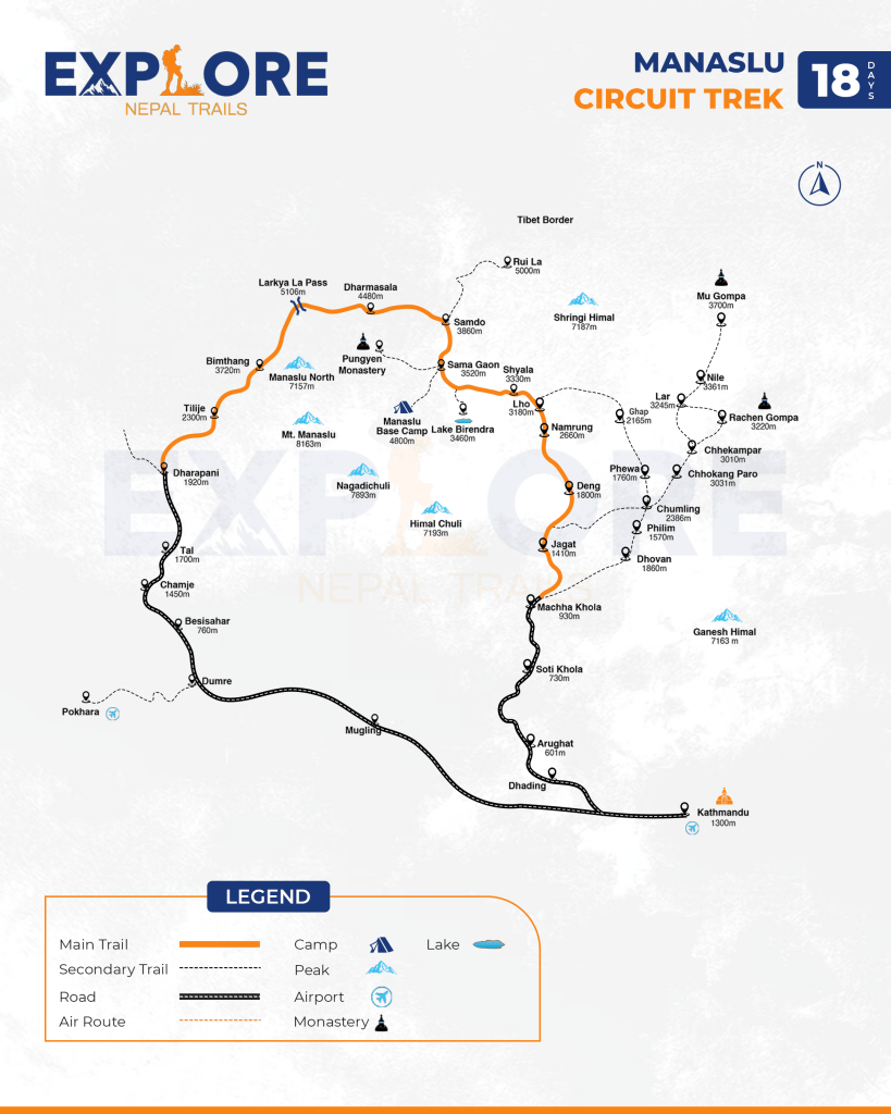
Drive Your destination to Manaslu Circuit Trek begins from Kathmandu. To start, you can take a direct bus at 6 am and 8 am, from Gongabu Bus Park, Kathmandu to Arughat. Or you can take the bus to Dhading or to Malekhu on the Prithvi Highway and take the local bus or jeep thereafter.
Although the road will be quite dusty and bumpy, you will catch the best landscape views from your window seat. En route, you can stop at many rests stops for short breaks and meals. Overnight at one of the teahouses in Soti Khola.
The next morning, you will enjoy the warm breakfast at the teahouse at Soti Khola while enjoying the scenic landscape. Then, you will start your trek of the day. Unlike other trekking trails, the road from Soti Khola to Machha Khola is quite rocky and narrow. With such experiences, you will reach Machha Khola to find many teahouses for a comfortable night’s stay.
The following day, you will start walking across the twisting road on the bank of Budi Gandaki river. As you enter the forest trail, you will witness many monkeys and langurs.
After the forest, you will walk to the Gurung villages, like lower Khorlabeshi. In the village, you will notice the shepherds clad in a typical smoke-browned cape called Bokkhu.
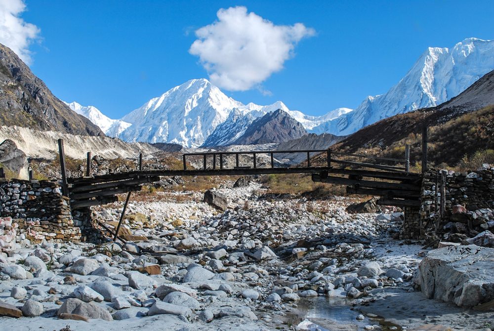
On walking further, you will reach Tatopani ‘hot water’ where you can take warm showers and relax your soaring body. After hot water relaxation, you will cross a new suspension bridge over Bhudi Gandaki river to reach Doban.
Following the waves, you will find the river flattening at Yaru from where you cross a long cantilever bridge to reach Jagat, a neatly flagstone Gurung village. On entering the village, you will have to verify your trekking permits at the check post there. From this day, you will be walking in the restricted region.
The next day, you will walk to Salleri and descend to Sirdibas. The village welcomes you with several gompas and Buddhist prayer flags. You can also try the local alcohol in many stopovers on the route before you reach Phillim. At Phillim, you will have your permits checked, and then you will continue along the western bank of the river.
The trail is beautiful with unique sculptures over the boulders on the river bank formed due to river water. Leaving the riverbank, you proceed through forests of rhododendron, Himalayan pine and the overhanging rocks on the towering peaks. These highlights beautify the trail. In the evening, you can gather around the fireplace and share your experiences with the fellow trekkers and locals before you go to bed.
After the sun rises up, you will have your breakfast and start the trek of the day. Before you ascend the winding trails, you will walk across the bamboo forest to reach Deng. Moving further, you will cross a suspension bridge to climb to Rana and Bihi Phedi. On the trail, you can see White Faced monkeys visiting villages on the lookout for a free feed.After the landslide zone, you will follow the trail up to Namrung.
After about 1hr on the uneven trail, you will climb a zigzag from the river to the neat village of Namrung (2660m). The place has some of the best teashops, a restaurant, and rest houses on the trek. A local businessman worked for over a decade in Hong Kong then returned to Namrung and built a restaurant and hotel that is modern.
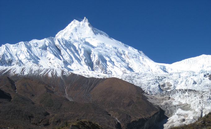
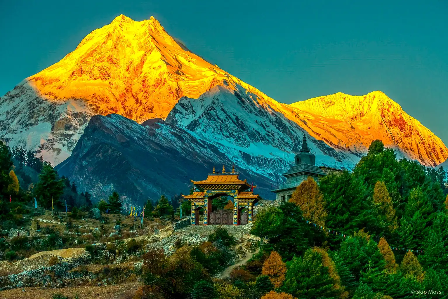
Witnessing the lifestyles of the Nubri people, you will start the day. Exploring their Tibet-influenced typical lifestyle you will walk past several mani walls, lush terraces, and houses through Banjam to enter the fir, rhododendron, and oak forest before climbing to Lihi then to Sho. From the place, you can catch the stunning views of Manaslu (8163m) and Manaslu North (7157m). On this day, you will gain a quite high altitude, so you must walk slowly and check your body signs.
The next morning, you will start with a day trip because of the altitude reasons. On walking, the picturesque view of Mt. Manaslu accompanies you. You will walk across the easy trail to Shyala on passing through pine and rhododendron gully with moss and gin-clear stream. From Shyala, you will walk for almost an hour to reach Sama Gaun.
Sama Gaun is the principal village of the Nubri people which holds a large gompa, many shops, a health post,
This is the day of acclimatization at Sama Gaon to prevent altitude-related illness. And, as an acclimatization hike, you will walk to Pungyen Gompa on the east of the Nubri Valley. On this acclimatization hike, you can bring your lunch and take it at the rest stops for energy. Like other days, you will walk across the roaring river which keeps you engaged for around 2 hours on the trail.
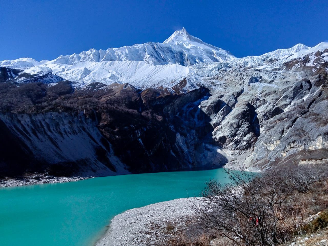
hike to Manaslu Base Camp which is in the north of Sama Gong. You can follow the trail past Birendra Tal and turn left onto the base camp track.
You will climb the steady trails; however, the altitude may cause breathing difficulty. So, you need to maintain body hydration and walk slowly. Proceeding slowly, you will walk to the north of Manaslu glacier to basecamp at 4400m then return.
On this new day, you will reach to the newer destination Samdo. But, as you are in high altitude, you need to walk slowly so, this is a short-day trek. You will notice extended yak pastures up a broad valley with long mani walls, with a variety of birds.
From there, you will leave the tree line and climb to a ridge across the wooden bridge of Buri Gandaki before you reach white Kani. It is a neighboring village to Samdo, a very picturesque village dedicated to yak herding.
you can explore the nearby villages or you can hike to Samdo Peak. The Larkya La trail is on the left above the valley. You can also see the main track for Tibet over the Larjyang La forming slopes on the Larkya La trail.
Once at the border, if you look towards the south of Samdo Glacier you will get excellent photos with a huge serac near the top of the glacier. You can also frame Blue Sheep, Pica’s, and Marmots in season.
This is another adventurous day in the high altitude. So, you must watch your body signs properly. Enjoying the scenic views of the chain of Himalayas you will walk slowly across the rugged terrains of the trek before you reach Dharmasala.
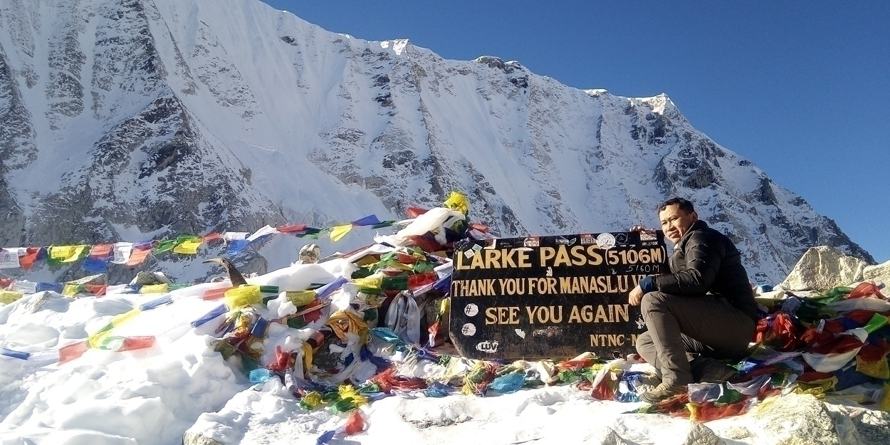
This is a special day as you will walk to the highest point of the trail. You will walk to Larkya La Pass (5160m) on this day. In bad weather and in the snow, the walk could be quite challenging yet, it is doable. You will cross the pass before afternoon so you need to wake up early and leave the teahouse quite early. This is the challenging part of the trek but if you walk steadily, you can walk to the pass successfully.
The stunning views you will witness once you stand at the pass make the trip more enlightened. You will catch views of Himlung (7126m) near Tibet and Kang Guru (6981m) and Annapurna II (7937m) in the Annapurna Range.
This is the final day you will be walking on the trails of the Manaslu region. On climbing downhill, you will walk through the lush forests full of flora and fauna including rhododendron bushes.
The valley becomes more agricultural and lusher as you pass fields and corpses of oak and rhododendron, staying on the north (true right) bank until Tilije. From there, you will continue your stroll towards Dharapani.
You will take a jeep from Dharapani to Beshi Sahar. From there, you will take a ride back to Kathmandu. After the 6 to 7 hours drive from Beshi Sahar, you will get to rest in one of the sophisticated hotels in Kathmandu.
Enjoy a free day to explore Kathmandu at your leisure. You can do some shopping for souvenirs, visit more of the city’s landmarks, or simply relax before your departure.
After a memorable manaslu circuit trek in the Manaslu region, you’ll be transferred to the airport for your flight home or to your next destination.


