Most people know Kanchenjunga as the third-highest mountain in the world. What few people realise is that it’s not really one mountain, it’s a whole family of peaks, glaciers, ridges, and valleys packed into one of the most dramatic massifs in the Himalayas, and there are peaks of Kanchenjunga.

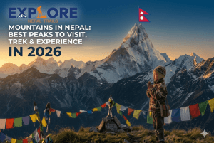
If you’ve been thinking about trekking in this corner of eastern Nepal, or you’re simply curious about what makes Kanchenjunga different from other Himalayan giants, this guide is for you. We’ll cover the main peaks, where the mountain actually sits on the map, what you’ll see from the trail, and what kind of food and accommodation to expect realistically.
It’s Not Just One Mountain; there are peaks of Kanchenjunga
This is the part that surprises most people. When you hear “Kanchenjunga,” you picture one great snow-covered peak. The reality is more interesting than that.
Kanchenjunga is a massif a large, interconnected mountain structure with multiple high summits, not a single pointed top. The main peaks that make up this group are:
- Kanchenjunga Main 8,586 m, the highest point, and the one everyone refers to
- Kanchenjunga West (Yalung Kang) 8,505 m
- Kanchenjunga South 8,494 m
- Kanchenjunga Central 8,482 m
- Kangbachen 7,903 m, a nearby peak closely tied to the wider region
Three of those summits clear 8,494 meters. Think about that for a moment. This mountain system has four separate peaks that are each, individually, among the highest points on Earth.
| Peak | Height | Notes |
| Kanchenjunga Main | 8,586 m | Third highest in the world |
| Kanchenjunga West / Yalung Kang | 8,505 m | Major summit on the western side |
| Kanchenjunga South | 8,494 m | Prominent on the southern approach |
| Kanchenjunga Central | 8,482 m | Connects the core of the massif |
| Kangbachen | 7,903 m | Nearby peak in the wider Kanchenjunga Himal |
Where are the peaks of Kanchenjunga located?
Kanchenjunga sits in the eastern Himalayas, straddling the border between eastern Nepal and Sikkim, India. On the Nepal side, the mountain is tied to the Taplejung district. On the Indian side, it’s the defining peak of Sikkim, and on a clear morning, you can spot it from Darjeeling, too distant but unmistakable.
This border position gives Kanchenjunga something of a dual identity. In Nepal, it’s a remote trekking destination, wild and rarely crowded. In Sikkim, it carries deep spiritual significance and is protected within the Khangchendzonga National Park.
For trekkers coming from Kathmandu, the journey to the Kanchenjunga region involves travelling quite far east before the actual trail begins. That remoteness is, for many people, the whole point.
Why Are There So Many Peaks?
Because of how massifs work. Unlike an isolated summit such as Ama Dablam, which rises dramatically from a single base, Kanchenjunga spreads across a wide area of connected rock, ice, and glaciers. Each “peak” is a distinct high point on this broader structure, with its own face, its own glaciers, and its own character.
This is also why Kanchenjunga looks completely different depending on where you’re standing. From Pangpema on the north side, you’re looking at a massive, cold, almost vertical mountain wall. From the Yalung Glacier side in the south, the mountain spreads out differently, flanked by Kabru and Rathong. From Darjeeling, the whole massif sits across the horizon like a white crown.
Same mountain. Very different experiences.
The Individual Peaks of Kanchenjunga, Up Close
Kanchenjunga Main
This is the summit, 8,586 meters, the third-highest point on the planet. When climbers or trekkers talk about “Kanchenjunga,” they usually mean this one.
What makes it special isn’t just the height. It’s the remoteness. Kanchenjunga sees far fewer expeditions than Everest or Manaslu, which gives it a rawness that the more trafficked peaks have lost. For trekkers heading toward North Base Camp, the view from Pangpema is the highlight, the main face of Kanchenjunga fills your entire field of vision.
Kanchenjunga West (Yalung Kang)
At 8,505 m, Yalung Kang is the western arm of the massif, closely associated with the Yalung Glacier on the southern approach. Trekkers heading to South Base Camp get to know this peak well. It looms large above the glacier and the high meadows around Ramche and Oktang.
Kanchenjunga South
Standing at 8,494 m, this is the dominant peak visible on the South Base Camp route. The southern approach to Kanchenjunga, passing through forests, remote villages, and eventually the Yalung Glacier, is partly shaped by this summit. It anchors the view from Oktang, which is one of the most rewarding viewpoints on the entire trek.
Kanchenjunga Central
At 8,482 m, the Central Peak doesn’t get as much attention as the others, but it’s a crucial part of the massif’s structure. It helps form the spine that connects the main group. You won’t necessarily identify it by name while trekking, but it’s there, filling in the ridgeline between the other summits.
Kangbachen and the Surrounding Area
Kangbachen (7,903 m) and other peaks like Jannu (Kumbhakarna), Kabru, Rathong, Nepal Peak, and Tent Peak surround the main massif and add to what makes this region so visually overwhelming. Some of these are separate mountains entirely, but they’re part of the landscape you’ll be walking through.
What Trekkers Actually See
The Kanchenjunga trek has two main sides, and they offer genuinely different experiences.
North Base Camp Side
The northern route passes through Ghunsa, Khambachen, Lhonak, and ultimately Pangpema at the base of the north face. This is the wilder, colder, more austere side. The mountain here is imposing in a way that’s hard to describe it doesn’t feel distant or picturesque it feels enormous and immediate.
Best for: trekkers who want the most powerful, raw mountain experience.
South Base Camp Side
The southern route takes you through varied terrain, forests, river valleys, and alpine meadows before arriving at Ramche and the Oktang viewpoint above the Yalung Glacier. Here you’re looking up at Yalung Kang, Kanchenjunga South, Kabru, and Rathong. The scenery is broader, and the landscape feels more layered.
Best for: trekkers who want scenic variety along with the mountain views.
The Full Circuit
If you want the complete picture, both sides of the mountain, the Kanchenjunga Circuit Trek or a combined North and South Base Camp route is the way to go. It’s longer and more demanding, but it’s the only way to understand the full scale of what Kanchenjunga actually is.
A Word on Climbing vs. Trekking on the peaks of Kanchenjunga
These are two completely different things, and it’s worth being clear.
Climbing Kanchenjunga is a serious mountaineering expedition. It requires technical skills, high-altitude experience, expedition infrastructure, and significant preparation. Very few people do it.
Trekking to Kanchenjunga Base Camp means walking through the region, through villages, forests, glaciers, and high-altitude viewpoints, to reach the base camp areas and see the mountain from the ground. No technical climbing required. Many experienced trekkers do this every season.
If you want to see Kanchenjunga without climbing it then trekking is the answer.
Trekking in peaks of Kanchenjunga: What You’re Actually Getting Into

The Kanchenjunga trek is one of Nepal’s most rewarding long-distance trails and one of the least talked about. That’s partly because it’s harder to reach than Everest or Annapurna, partly because it requires a restricted area permit, and partly because the infrastructure is genuinely more basic. But for trekkers who’ve already done the popular routes and want something that feels real and unfiltered, Kanchenjunga is in a different league.
The region sits in far eastern Nepal, accessible via a flight to Bhadrapur or Suketar (Taplejung) followed by a drive or walk to the trailhead. From the moment you leave the road behind, the trail feels different quieter villages, fewer other trekkers, forests that haven’t been thinned out by decades of teahouse firewood, and a mountain that you approach gradually over days rather than seeing plastered across every guesthouse wall.
There are three main ways to trek in this region, each with a distinct character.
Kanchenjunga North Base Camp Trek
The Route
The North Base Camp trek takes you into the heart of the Kanchenjunga massif from the northern side. The trail climbs through the Tamur River valley, passes through the ancient trading village of Ghunsa, and eventually leads you up to Lhonak and then Pangpema, the North Base Camp at roughly 5,143 meters.
Pangpema is the highlight. Standing there, with the massive north face of Kanchenjunga filling your entire view, surrounded by glaciers and silence, is an experience that’s genuinely hard to put into words. The mountain feels close in a way that photographs never quite capture.
A typical itinerary runs from Taplejung through Sekathum, Amjilassa, Ghunsa, Khambachen, Lhonak, and up to Pangpema, before retracing back.
Duration
Approximately 12 to 18 days, depending on your pace, acclimatization days, and starting point. Most itineraries build in rest days at Ghunsa (around 3,595 m) to acclimatize before pushing higher.
| Stage | Approximate Days |
| Travel to trailhead (Kathmandu to Taplejung) | 2–3 days |
| Taplejung to Ghunsa | 4–5 days |
| Ghunsa acclimatization | 1–2 days |
| Ghunsa to Pangpema (North Base Camp) | 2–3 days |
| Return trek | 3–5 days |
| Total (trek only) | ~12–18 days |
What Makes the North Side Worth It
- The north face view from Pangpema is the defining moment of this entire route a direct, unobstructed look at Kanchenjunga Main from below
- The Kangchenjunga Glacier and the high valley between Lhonak and Pangpema offer some of the most dramatic high-altitude landscapes in Nepal
- Ghunsa village is a genuinely beautiful Tibetan-influenced settlement with a gompa (monastery), stone houses, and a slower pace of life that rewards an extra day
- The trail passes through the Kanchenjunga Conservation Area, so wildlife sightings of red panda, snow leopard tracks, and Himalayan tahr are more possible here than on more trafficked routes
- You’ll share the trail with very few other trekkers, especially outside of peak season
Things to Know Before You Go
The north side is colder, more exposed, and more demanding than the south. The section from Lhonak to Pangpema sits at a high altitude with limited shelter from wind. Acclimatization is not optional here, rushing it leads to problems. Come prepared with proper cold-weather gear, a quality sleeping bag, and realistic daily walking expectations.
Kanchenjunga South Base Camp Trek
The Route
The South Base Camp route approaches Kanchenjunga from the southwest, following a different valley system and offering a completely different visual experience of the mountain. The trail passes through villages like Yamphudin and Tortong before climbing to Ramche and finally Oktang, the South Base Camp viewpoint at around 4,780 meters.
From Oktang, you’re looking directly at the Yalung Glacier, with Kanchenjunga South and Yalung Kang (Kanchenjunga West) dominating the skyline, flanked by Kabru and Rathong. It’s a wider, more expansive mountain panorama than the north side, less of a wall, more of a kingdom spread out in front of you.
The descent from Ramche and the route back give you time to appreciate the lower forests and river valleys that form the approach rhododendron forests, river crossings, and the kind of terrain that reminds you why people trek in the first place.
Duration
Approximately 12 to 18 days, slightly overlapping with the northern route, depending on pace and acclimatization.
| Stage | Approximate Days |
| Travel to trailhead (Kathmandu to Taplejung/Suketar) | 2–3 days |
| Taplejung to Yamphudin | 2–3 days |
| Yamphudin to Oktang (South Base Camp) | 3–4 days |
| Return trek | 3–4 days |
| Total (trek only) | ~12–18 days |
What Makes the South Side Worth It
- Oktang viewpoint offers one of the most photographed mountain panoramas in Nepal: Yalung Kang, Kanchenjunga South, Kabru, Rathong, and the Yalung Glacier, all visible from one spot
- The approach through rhododendron and bamboo forests at lower elevations is genuinely beautiful, especially in spring when the rhododendrons are in bloom
- The southern route has more landscape variety, as you transition from subtropical forest to alpine terrain to glacial moraine over the course of the trek
- Yamphudin is a charming village with Limbu and Rai cultural influences, and a good place to understand the lower-altitude life of this region
- The south side is generally considered slightly less cold and exposed than the north, making it a reasonable starting point for trekkers newer to high-altitude terrain
- Wildlife in the lower forests is rich, with red panda sightings more commonly reported here than on many other Himalayan routes
Things to Know Before You Go
The south route doesn’t reach the extreme altitudes of the north, but it’s still a serious trek. The high sections around Ramche and Oktang require proper preparation, and the lower sections involve river crossings and forest terrain that can be demanding after rain. Don’t underestimate it because the maximum elevation is lower, the cumulative effort over two-plus weeks adds up.
Kanchenjunga North and South Base Camp Trek (The Full Circuit)
The Route
This is the complete Kanchenjunga experience, a single trek that takes in both the northern and southern sides of the massif, connected by a high mountain pass called Sele La (around 4,290 m) and sometimes the Mirgin La route.
The logistics can be arranged in either direction, starting from the north and finishing south, or starting south and going north, though starting north and finishing south is slightly more common, as it allows trekkers to acclimatize gradually before tackling the high points.
The route connects all the key highlights: Ghunsa, Khambachen, Lhonak, Pangpema, then crossing over toward the south side through high passes, descending to Ramche, Oktang, and Yamphudin before finishing.
It’s a demanding trek and requires solid experience at altitude, good physical preparation, and more logistical planning than either single route. But it’s also the only way to see Kanchenjunga as a complete mountain to understand how its different faces relate to each other, how the glaciers flow down different valleys, and why four separate peaks above 8,400 meters can feel like one coherent, overwhelming presence.
Duration
Approximately 20 to 25 days, including travel days and acclimatization.
| Stage | Approximate Days |
| Travel to trailhead | 2–3 days |
| North Base Camp approach and return to Ghunsa | 8–10 days |
| Crossing via Sele La / Mirgin La to south side | 2–3 days |
| South Base Camp approach and return to the finish point | 5–6 days |
| Total (trek only) | ~20–25 days |
Why the Full Circuit Changes the Way You See the Mountain
There’s a specific moment on the circuit that most trekkers talk about: crossing from the cold, austere north side over the high pass and beginning the descent toward the warmer, more forested south. The landscape shifts entirely. The mountain behind you looks different from the mountain ahead of you. And somewhere in that transition, you understand that what you’ve been walking around is one of the genuinely great mountain systems on Earth.
Key benefits of the full circuit:
- You see Kanchenjunga from every major angle the raw northern face, the glacier-filled south, and the connecting ridges in between
- The high pass crossing (Sele La or Mirgin La) is a dramatic high point of its own, with wide views, complete silence, and the feeling of genuinely crossing from one world into another
- You visit every major highlight: Pangpema, the Kangchenjunga Glacier, Lhonak, Khambachen, Ghunsa, Ramche, Oktang, and the Yalung Glacier
- The variety of terrain from high Arctic-feeling glacial valleys to forest-covered lower hillsides is greater than almost any other single trek in Nepal
- It’s genuinely off the beaten path. Even during peak season, you can walk for hours on the connecting route without seeing another trekking group
- For experienced trekkers, it’s one of the most satisfying long mountain journeys available anywhere
Things to Know Before You Go

This is a serious, multi-week undertaking. The high pass section requires confidence in rough terrain, solid weather windows, and careful acclimatization on the north side before attempting the crossing. The total distance, cumulative elevation gain, and duration mean that physical preparation matters. Having done multi-day high-altitude trekking before, or build in extra buffer days. An experienced local guide is not optional here, it’s essential.
| Route | Duration | Max Elevation | Best For |
| North Base Camp | 12–18 days | ~5,143 m (Pangpema) | Raw mountain power, the north face, glacial drama |
| South Base Camp | 12–18 days | ~4,780 m (Oktang) | Landscape variety, Yalung Glacier panorama, slightly gentler approach |
| Full Circuit (North + South) | 20–25 days | ~5,143 m + high pass | Complete Kanchenjunga experience, both sides, most rewarding |
Accommodation on the Trek: What to Honestly Expect
Kanchenjunga is not Everest Base Camp. There are no bakeries mid-route, no lodges with heated common rooms, no espresso menus. But there are teahouses, local guesthouses, and homestays across most of the route and if you go in with realistic expectations, they’re perfectly fine.
Lower Elevations
In the lower villages, accommodation is basic but functional: twin-sharing rooms, simple mattresses, shared toilets, and a common dining room. Some places have hot showers or bucket hot water. Charging is usually possible, sometimes for an extra fee.
Mid-Route Villages (Ghunsa and Similar)
Ghunsa is often considered the most comfortable stop on the northern route. The teahouses here are better organized, food choices are wider, and it’s the natural acclimatization stop before heading higher. A few places here may even offer Wi-Fi, though don’t count on it being reliable.
High Altitude
Above Ghunsa, and on the high sections of the southern route, accommodation becomes much more stripped back. You’re looking at small, cold rooms, shared outdoor toilets, limited menus, and no hot water. The word “comfort” at these elevations means: a dry place to sleep, warm food, and protection from the weather. That’s genuinely all it means.
Is There Luxury Trekking in Kanchenjunga?
Honest answer: no, not in the way “luxury” works on some parts of the Everest or Annapurna routes.
What you can do is plan a comfort-focused trek with better hotels in Kathmandu before and after, best available lodges on the trail, private rooms where they exist, a good sleeping bag, experienced guide and porter support, and pre-arranged logistics. That’s not luxury in the resort sense, but it’s the difference between a stressful remote trek and a well-supported one.
| Budget | Best-Available Comfort | |
| Room | Basic twin-sharing | Private room where possible |
| Toilet | Basic shared | Better shared where available |
| Bedding | Simple blanket | Better bedding + personal sleeping bag |
| Food | Standard dal bhat and noodles | More variety in larger villages |
| Support | Basic guide/porter | Experienced guide, better logistics |
Food on the Trail
The food in Kanchenjunga is simple, warm, and filling. That’s exactly what you need.
Dal bhat rice, lentil soup, vegetables, and pickle are the cornerstone of every teahouse menu and for good reason. It’s nutritious, freshly cooked, and almost always available. Many trekkers eat it twice a day and don’t regret it.
Other things you’ll find on most menus:
- Noodles (soup or fried)
- Fried rice
- Potato dishes
- Tibetan bread and chapati
- Eggs boiled, fried, or in an omelet
- Porridge
- Thukpa (Tibetan noodle soup)
- Tea, coffee, hot lemon, ginger tea
Breakfast is usually simple: tea, porridge, Tibetan bread, or eggs. Don’t expect fresh juice, granola, or a spread of options, especially above the lower villages.
Vegetarian food is generally easy to find since the staples are naturally plant-based. Vegan options are possible but need to be clearly communicated, as butter, milk, and eggs appear in many dishes without being announced.
If you have specific dietary needs, carry backup food from Kathmandu. The higher you go, the shorter the menu gets.
Practical Facilities
Toilets: Shared and basic throughout. In lower villages, slightly better. Higher up, often a simple structure outside the main lodge.
Showers: Not guaranteed. Some lower villages have hot showers or bucket hot water available for a fee. Higher up, expect cold water at best.
Wi-Fi: Limited and unreliable. Larger villages like Ghunsa might have connectivity, but plan to be offline for most of the trek.
Charging: Available in some lodges, often at an extra charge. Bring a power bank, it matters more here than on most treks.
Tips for a More Comfortable Trek
A few things that genuinely make a difference:
- Bring a quality sleeping bag rated for cold temperatures
- Add a sleeping bag liner for extra warmth
- Pack snacks from Kathmandu (chocolate, nuts, energy bars)
- Carry a reliable power bank
- Bring water purification tablets or a filter
- Layer up nights at altitude, it gets very cold, even in season
- Trek with a local guide who knows the region
- Stay flexible, supplies, room availability, and weather all vary
Why Kanchenjunga Is Worth It
In an era when Everest Base Camp feels like a busy hiking trail on a summer day, the peaks of Kanchenjunga are something else entirely. The trails are quieter. The villages feel more traditional. The mountain views are unfiltered and close.
The name Kanchenjunga is often said to mean “five treasures of snow,” referring to its five prominent peaks and the gold, silver, gemstones, grain, and holy scriptures said to be hidden within the mountain. Whether or not you follow that mythology, it says something about how this mountain has been perceived for centuries, not just as terrain, but as something larger than itself.
For trekkers, those five peaks translate into something more concrete: a mountain that looks different from every direction, that reveals itself slowly over days of walking, and that doesn’t feel like it’s been packaged for you.
If you can handle a remote trek with basic accommodation and simple food, Kanchenjunga will give you one of the most honest and memorable Himalayan experiences available.