Published August 31, 2026. This explainer is compiled from official Nepal government sources, USGS analysis, and verified news reporting. Figures and technical details are attributed to their original source throughout; see the Sources section at the end for direct links to primary, authorised channels. This is a developing story and will be updated as new official information becomes available.
On the morning of August 26, 2026, at roughly 8:37 a.m. Nepal time, a wall of ice, rock, mud, and water tore down the Lhende Khola valley on the Nepal-Tibet border named as Nepal Flash Flood 2026. Within hours, it had devastated three districts, caused a significant loss of life, and wiped out entire sections of Nepal’s road network to China. This wasn’t a monsoon cloudburst in the usual sense. It started 20 kilometers upstream, in Tibet, with a chunk of glacier the size of a small mountain giving way. Here is the technical chain of events, from the ice high in the Himalaya to the mud in the streets of Trishuli Bazaar.
Where it started: a glacier, not a storm
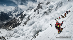
Flash floods in Nepal are usually blamed on monsoon downpours. This one wasn’t. Investigators, including the US Geological Survey(USGS) and geophysicists at Columbia University’s Lamont-Doherty Earth Observatory, traced the trigger to an ice-rock avalanche: a large mass of glacier detached from its bed high above the Lhende River on the Tibetan side of the border, near Langtang Lirung, and came down the mountainside as a combined landslide and ice fall.
This is mechanically distinct from two other hazards people often lump together:
- Glacial Lake Outburst Flood (GLOF): an existing lake, dammed by ice or unstable glacial debris (moraine), suddenly releases its stored water when the dam fails.
- Glacier collapse / ice-rock avalanche: a mass of glacier ice, sometimes with the underlying rock or permafrost slope attached, detaches and falls independent of any pre-existing lake.
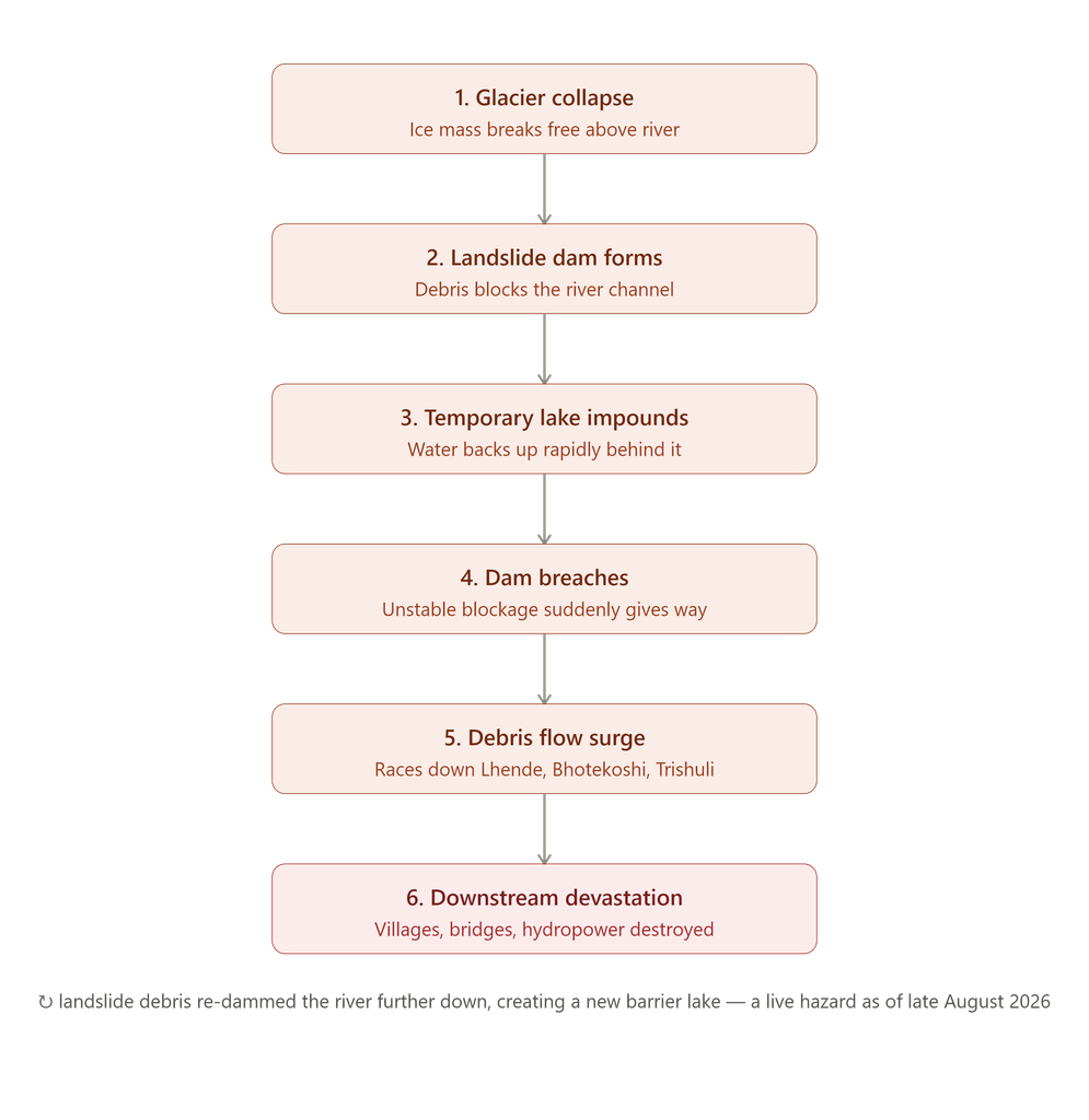
In this case, the glacial collapse triggered flash floods, mudslides, and a barrier lake where a landslide dammed the river. In other words, the sequence ran: ice/rock avalanche → temporary landslide dam → lake formation → dam breach → flash flood, a “cascading hazard chain” rather than a single event.
Why the ice let go
Two forces are usually blamed for this kind of failure in the high Himalaya:
- Permafrost degradation. The rock and ice on steep high-altitude slopes are often held together by frozen ground acting like natural cement. As average temperatures rise, that cement thaws, and slopes that have been stable for centuries lose their grip.
- Glacier thinning and destabilization. As glaciers lose mass from the surface down, the remaining ice becomes more fractured and prone to sudden calving or slope failure, especially on steep, debris-covered tongues like those below Langtang Lirung.
Climate change contributes to the melting of permafrost, which in turn increases the likelihood of glacier collapses. Scientists interviewed by Reuters and the BBC in the days after the event said warming almost certainly played a role, even though attributing a single collapse cleanly to climate change takes more study.
The seismic signature
Because the initial mass movement was so large, it registered on seismometers designed to detect earthquakes. The landslide from the collapse registered as 5.2 on the Richter scale on local seismometers. Authorities initially thought an earthquake had struck the region. The US Geological Survey later announced that the landslide itself had generated the seismic energy and that no tectonic earthquake had occurred, a useful reminder that mass-movement events of sufficient scale (avalanches, landslides, glacier calving) can generate earthquake-like signals purely from the physical impact and friction of moving rock and ice.
From ice avalanche to river surge: the hydraulic chain (Nepal Flash Flood 2026)
Here is where the geophysical event became a hydrological one.
- Damming. Analysis showed that the ice landslide blocked a section of the Lhende Khola River, a tributary that feeds into the Bhotekoshi system, forming a temporary lake. This is a classic landslide dam or barrier lake: loose, poorly consolidated debris (a mix of ice, rock, and soil) acting as a plug across a river channel.
- Impoundment. Water backed up rapidly behind this improvised, unstable dam. Unlike an engineered dam, a landslide dam has no spillway, no compaction, and often contains blocks of ice that are actively melting, making it inherently unstable and prone to fail within hours to days of forming.
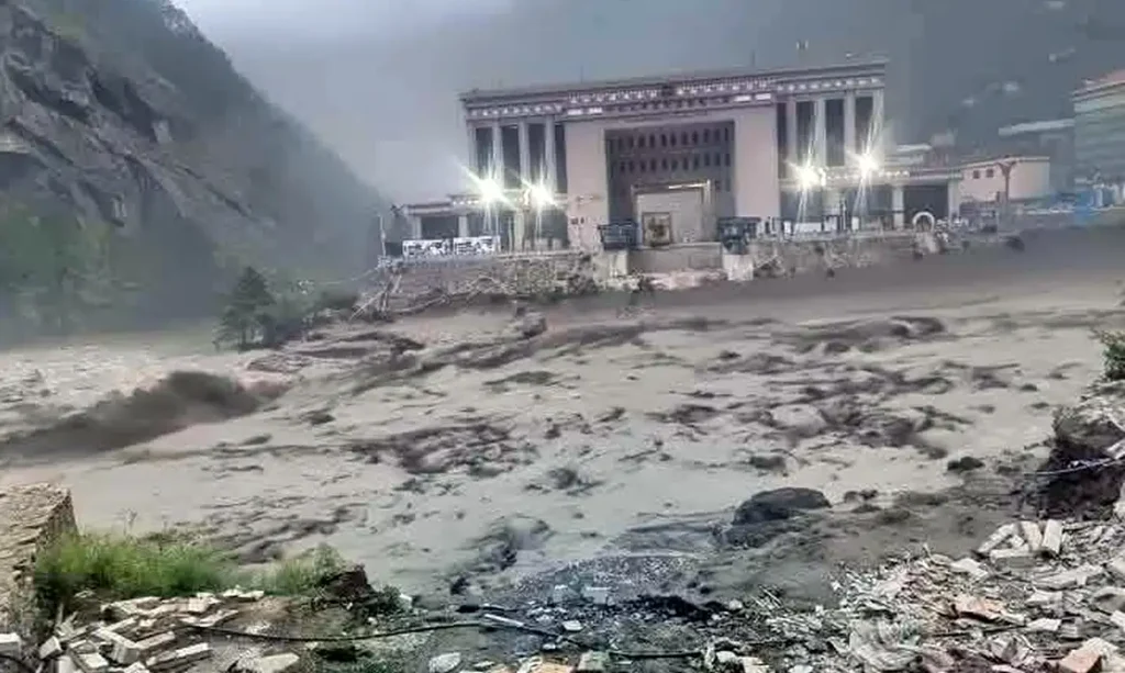
- Breach. The dam gave way, releasing the impounded water plus the surrounding loose debris it entrained, all at once, as a debris flow rather than a “clean” water flood. This is why survivors describe the flood as a wall of mud and boulders rather than a rising river.
- Downstream cascade. The surge tore through settlements in Nepal’s Rasuwa district, destroying homes, hydropower plants, and border infrastructure, after striking the river about 20km northeast of the Rasuwagadhi border crossing. The flood then followed the natural river network: the initial surge entered the Lhende Khola, which feeds into the Bhote Koshi and then the Trishuli River, carrying floodwaters south through Nepal.
How fast did it rise?
The numbers here illustrate why this is called a “flash” flood rather than ordinary river flooding. Water levels in the Trishuli reportedly rose by as much as 9 metres (30 feet) in just 30 minutes. Downstream communities had essentially no warning window; by the time the surge was visible or audible, residents had minutes, not hours, to reach higher ground. Floodwaters reached settlements as high as 80 metres (270 feet) above the normal river level in places.
Why the warning systems missed it
Nepal, like other Himalayan nations, has invested in early-warning sensor networks along major rivers, but this event exposed a structural blind spot. The system proved incapable of detecting the disaster in time because the water-level monitors were optimized for detecting monsoon floods or perennial floods, not a sudden ice-dam-and-breach event originating from a remote, unmonitored tributary. Worse still, upstream monitoring stations in Nepal were swept away by the flooding before any alerts could be sent downstream. A researcher at the Stimson Centre described the source area as a monitoring “blind spot,” a remote high-altitude tributary that received little attention from glaciologists precisely because it wasn’t known to host a large, classically “dangerous” glacial lake.
This is a recurring theme in Himalayan disaster science: existing GLOF hazard inventories (like the widely cited count of roughly 3,600+ glacial lakes across Nepal, India, and Tibet, with several dozen flagged as “potentially dangerous”) are built around known, mapped lakes. This event wasn’t a known lake bursting. It was a landslide creating a brand-new, unmapped one and then failing almost immediately.
The damage, district by district
The flood cut a path through Rasuwa, Nuwakot, Dhading, Gorkha, and Chitwan districts in Bagmati province. The worst-hit areas were along the Rasuwagadhi-Syaphrubesi-Timure corridor, which also happens to be Nepal’s main overland trade and pilgrimage link to Tibet (used heavily by Kailash pilgrims and cross-border traders).
Human toll: Search and rescue operations remain ongoing, with thousands of personnel deployed and thousands rescued. A significant number of people, including many foreign nationals, remain unaccounted for. For the current official figures, refer to NDRRMA’s live updates linked in the Sources section below rather than any static number here; the situation is still developing.
Infrastructure toll:
- Nepal’s government put preliminary damages at roughly Rs 200 billion (approximately $1.4-1.5 billion USD)
- An initial Roads Department estimate alone put road and bridge losses at about Rs 15 billion, affecting 41 bridges and roughly 42 km (26 miles) of road
- 14 hydropower and solar projects were affected, with a combined generating capacity of about 748 megawatts
- The entire road connecting Betrawati (Nuwakot) to the Rasuwagadhi border crossing, Nepal’s key link to China, was destroyed
- Telecommunications networks, water systems, and border-crossing infrastructure at Gyirong Port were badly damaged
Not an isolated event: a pattern
This disaster fits into a well-documented and worsening pattern in the high Himalaya:
- 2015 Langtang debris avalanche: Triggered by the Gorkha earthquake, a glacier collapse near Langtang Lirung, the same massif implicated in the 2026 event, buried the entire village of Langtang with substantial loss of life.
- 2023 South Lhonak GLOF (Sikkim, India): A glacial lake that had grown steadily since the 1970s as its parent glacier retreated finally breached, causing significant loss of life and destroying a major hydroelectric dam.
- 2024 Thame GLOF (Solukhumbu): Two glacial lakes near Mount Everest burst in August 2024, damaging the Sherpa village of Thame.
- July 2025 Rasuwagadhi flood: A GLOF from a supraglacial lake in Tibet swept away the Nepal-China Friendship Bridge at the exact same border crossing, devastated again in 2026.
- August 2025 Uttarakhand flash flood (India): A combination of a possible cloudburst, glacier collapse, and landslide devastated Dharali village.
The recurrence at the same border crossing within just over a year (2025’s GLOF and 2026’s glacier collapse) underscores that this isn’t bad luck striking a random valley. It’s a structurally unstable high-mountain zone (steep glacier-covered terrain, permafrost, active tectonics) experiencing more frequent failures as warming accelerates.
The danger isn’t over: the new barrier lake
Perhaps the most technically concerning postscript is that the landslide which caused the flood also created a new debris dam further downstream, forming a fresh barrier lake that didn’t exist before August 26. Officials warned within days of the disaster about the possibility of a dam burst as debris-clogged rivers continued filling with water, raising concerns about a second wave of flooding. This is a common and dangerous secondary hazard after large landslide/avalanche events: the same loose, unconsolidated debris that caused the first flood often re-dams the river lower down, setting up a second failure once the new lake fills.
Nepali authorities are now treating this new lake as an active hazard requiring monitoring and, likely, controlled drainage: the same kind of intervention (siphon pipes, controlled breaching) used on lakes like South Lhonak before 2023, when engineers tried and ultimately failed to lower the lake fast enough.
The bigger picture
What makes this event a useful case study isn’t just its scale. It’s what it reveals about the limits of current hazard monitoring in the Himalaya. Existing systems are built to catch known dangerous lakes and monsoon-driven river flooding. This event was neither: it originated from an unmapped, unmonitored slope failure that created and destroyed a lake in the same day. As permafrost thaw and glacier retreat continue across the region, similar “blind spot” failures sudden, cascading, and outside the standard warning framework, are likely to become more common, not less.